CAPE YORK - THE NORTHERNMOST POINT
A circumnavigation of the Australian continent wouldn't be complete without a trip to the "Tip", the northernmost point of the Cape York Peninsula. Due to the late wet season, we weren't really sure how far up the unpaved track we could get or which of the roads were open - even local authorities had no reliable information. After prepping our car for a long, rough trip and stocking up with supplies for 3 weeks, we were ready to give it a go!
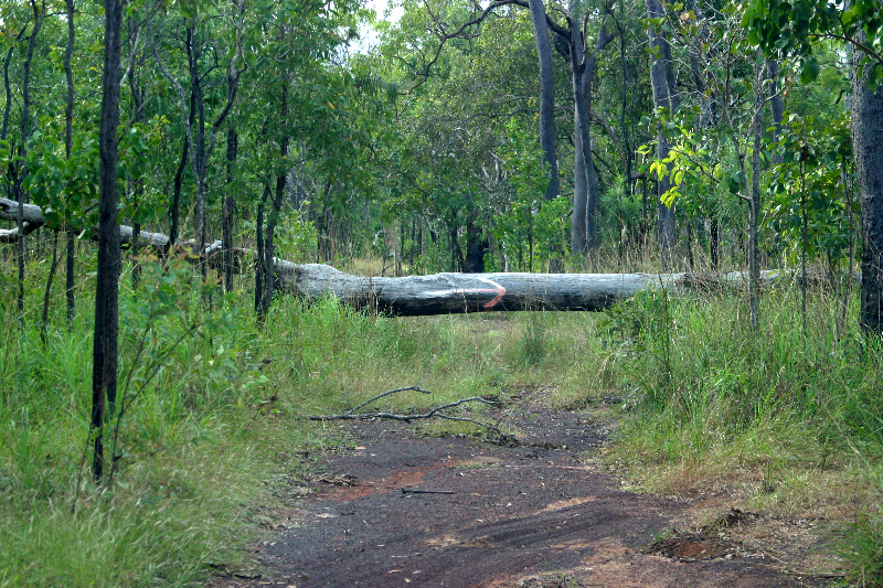
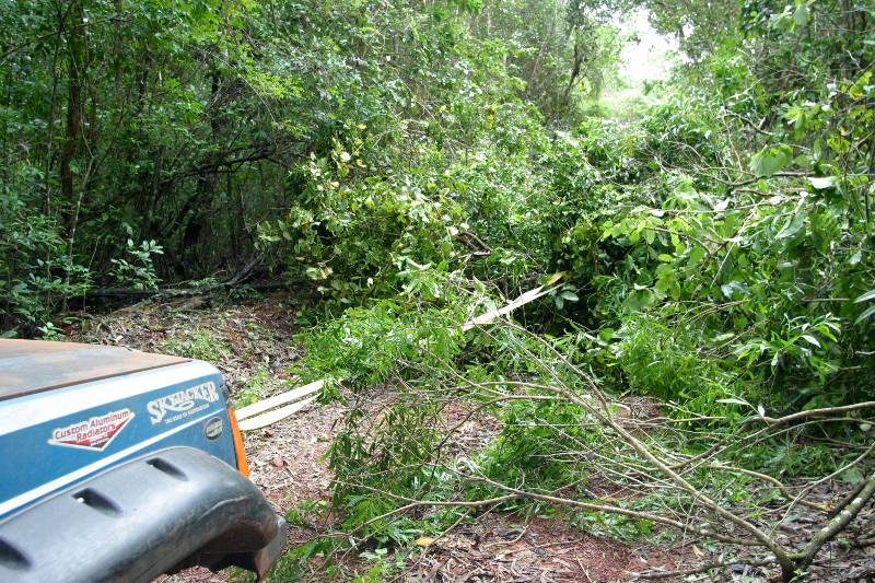
The Cape York Peninsula is a region of incredible beauty with its dense forests (pic01), wetlands and scenic coastline. It exerts an unresistable attraction for the adventurous soul due to its remote, tough tracks with multiple deep water crossings and offers an opportunity to view the numerous islands in the Torres Strait from the tip which is only some 150km south of Papua New Guinea. Many of its plants and animals are not found anywhere else in the world.
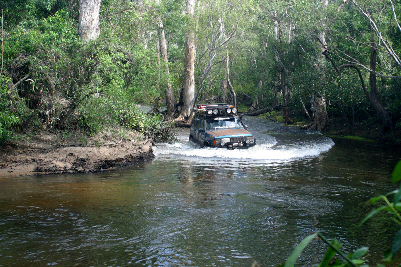
The first half of the track was in surprisingly good condition as road crews were still busy grading and filling in washed-out sections. We only had one deep crossing where a wetland area had swapped over the road, promptly leaking into our truck because our front doors don't seal too well. Once the road branched off to Weipa, a mining town on the west coast of the peninsula famous for its fishing, the track gradually became more rutted and narrower. As we were heading north, we stopped at every roadhouse to enquire about the track conditions further on. We had been told that due to weight limits on the road, some of the service stations had gotten low on supplies but found them all fairly well stocked. It was a long weekend, with Queen's birthday being celebrated on Monday (a holiday which, incidentally, is not observed in the UK, nor is it attributed to the correct date), and some traffic was moving north but most of the vehicles were headed for Weipa. Finally, we reached the junction where we were hoping to gain access to the ultimate adventure trail: the Old Telegraph Road (OTR), opened around 1872 to maintain a now-defunct telegraph line. The wider Bypass Road has been available to vehicles since the 1960ies and the OTR slowly deteriorated to a state that makes every four-wheeler's heart beat faster. The narrow and winding trail hadn't been maintained since the bypass opened and features tricky wash-outs and deep river crossings (pic02) and is only for the experienced and well-prepared. Up to this point, we had not been sure if the track was open at all; rumors abounded of chest-high water crossings and impassable sections. We were ready to see for ourselves and were accompanied to the first river crossing by a retired national park ranger driving a Land Rover who wanted to take a picture of "the American product going down", as he joked. After taping our doors shut to prevent more water intake and padding the inside of the sills with our beach towels, we climbed into the truck through the windows (our only way in and out for the next few days) and gave it a go. In the meantime, a little group of hopeful travelers had joined us and one of them had already walked the creek so we knew its actual depth. Since the water is very clear and presumed depth deceptive, it is essential to walk these creeks - not a tempting concept in crocodile country! We pushed through the water and emerged safely (with dry interior) on the other side to the cheers of the bystanders. While they returned to the roadhouse, we pushed on north.
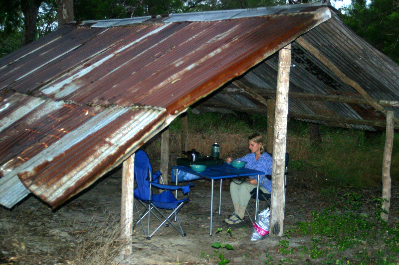
Over the next few days, this would be our pattern: Tackle the challenges of the track, scout out the many river crossings and find a safe passage, then go for it. Every water crossing was different: one had a patch of quicksand right after the entrance into the creek; another involved driving an S-shape through the water to avoid falling into large holes in the otherwise flat rock slab; yet another was hip-deep with strong current. Between the trees, we ripped through countless spider webs weaved across the tracks and ended up with several unwelcome passengers (pic03). The track was mostly wet as it rained on and off the entire time, but it remained warm enough that we were tempted to take a swim in some of the safe swimming holes (rock holes that crocodiles couldn't climb into). Vegetation was at its prime and everything was very green and lush. At night, we found a secluded campsite, covered our rig with a large tarp to keep the rain away from the open windows and enjoyed a campfire. Once we lucked out with a shelter built by a local 4WD club which provided some refuge from the incessant drizzle (pic04).
Further north, the OTR connects briefly with the Bypass Road before going off on its own adventure again. While we hadn't met anyone on the southern section of the track, a couple of waterfalls drew some travelers from the graded road and a portion of the northern section of the OTR got more traffic. Soon after Eliot Falls we reached Mistake River, so named by locals after what they think of anyone's decision to go further. The track became severely washed out and clearly hadn't been driven by anybody in a long time. It was time to take the turnoff road to the Bypass and make way for the ferry across the Jardine River. Towards the end of the Dry, when river levels are at their lowest, some extreme adventurers attempt crossing the river in their own vehicles but too many rigs have been lost and even lives taken by crocodiles that this would seem a viable alternative. At any rate, with this year's record floods, driving across the river would be impossible for several more months if at all.
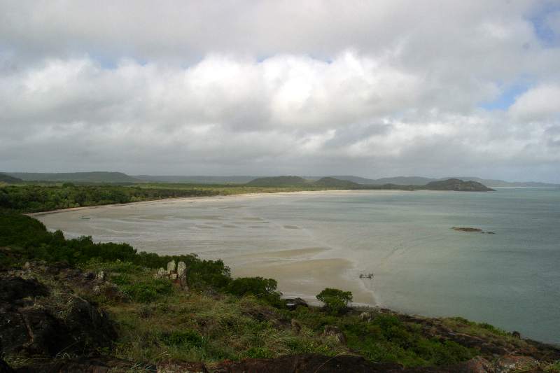
In Bamaga, we were chatting with the extremely knowledgeable local at the Visitor Center when a tour group arrived to visit his museum. We gladly accepted his spontaneous invitation to join the tour and learned a lot about local history. Islanders from Papua New Guinea settled in this area in the late 40ies and indigenous people - Islanders and Aboriginals - make up over 95% of the population up here. Then we pushed on to the northernmost point, marked by a sign on the edge of a cliff overlooking Torres Strait. The view up here was phenomenal (pic05)! On a narrow track through dense rainforest, we made our way towards Somerset beach when we found a tree blocking the way. With winch and straps, we cleared the path and continued on (pic06). After a relaxing break in the cove with the delectable treat of a coconut fresh from the tree, we continued along the track, crossing several beaches until it veered back inland.
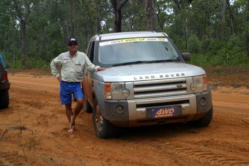
Eventually, it was time to
head back south. Just past the ferry, we met one of the vehicles from
the four-wheeling magazine out to elect the stock 4WD of the year (pic07).
Dion had lived in this area for years and had lots of insight for us.
He was the unfortunate member of the team picked to drive the crippled
Land Rover via the Bypass Road to a meeting point.
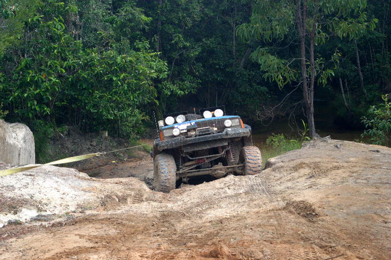
Moving on, we decided to take the OTR back south as we had enjoyed it
so much. Gunshot Creek, an infamous obstacle because of its steep drop
into the creek which we had to climb up going south, proved too slippery
and wet and we had to winch it up (pic08). Further south, we encountered
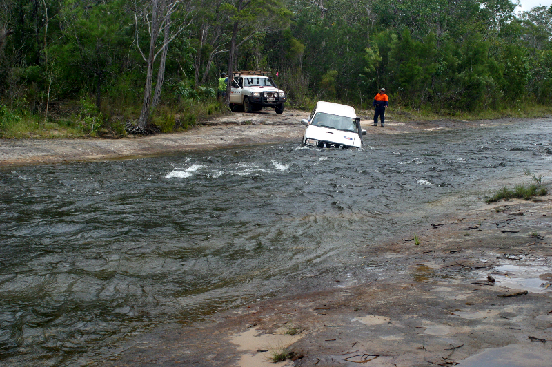
a group of 3 vehicles from the Australian telephone company Telstra who
were scouting the region to lay new cables. One truck tried to take a
shortcut through one of the deeper creeks and got stuck (pic09); when
his buddies had pulled him out, the water was gushing out the cabin. We
were surprised to see that even a brand-new vehicle had its leaks...
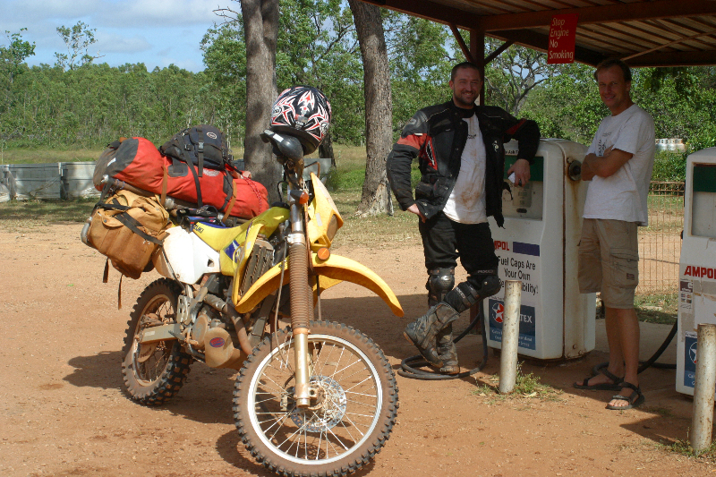
As we were getting further south, the clouds started to clear out and we finally saw some blue sky for the first time in almost 2 weeks. This was particularly good news for the numerous motorcyclists enjoying themselves on the road. As Anthony from Sydney put it (pic10): "I've been wet for the last 2 weeks!"
The Peninsula Development Road had taken quite a beating in the meantime as traffic was increasing. We got a better understanding of how quickly the corrugation got worse and road conditions deteriorated. If it changed that much in just one week, we could only imagine what it would be like at the end of the Dry!
Almost two weeks after our departure from Cairns, we rolled back into civilization. A short detour took us back to our Italian coffee-making acquaintance (see Segment 10) where we savoured our first caffeine fix in 10 days. A phone call later we followed a spontaneous dinner invitation by our friends Christine and Peter and wrapped up our adventure with a sumptuous meal.
With its scenic beauty and adventure opportunities, the Cape York excursion was certainly a highlight of this trip. We are sad to report that the fun might soon be taken out of this track. For years, the Australian government has been in negotiations with Papua New Guinea to import natural gas, and Chevron has been hired to run the pipeline down the peninsula. Since the Aboriginal communities are charging Chevron an arm and a leg to run the pipeline through their lands (AU$1 Mio per kilometer!), the company is planning to make use of an easement along the Old Telegraph Road. To maintain the pipeline, they would grade the track and bridge the crossings and that would be the end of one of the last great adventures. Supposedly, this project could start as early as this year...
pic01
pic02
 pic03
pic03

pic04
pic05
pic06
 pic07
pic07
pic08
pic09
 pic10
pic10
for more pics click here